
Mamquam Falls – Squamish
Mamquam Falls is a pretty waterfall in Squamish at the end of an impressive gorge. It has beautiful glacial-fed waters, so looks amazing, even on moody, grey days. You can do the trail as a loop and it is short, and relatively easy to reach in all seasons.
This location is sometimes called a “hidden gem” but it is pretty popular on Instagram for the last couple of years, and you can find it on all trails so it’s not hidden. The main thing to note is the waterfall is right next to a power station, so this might not be the wilderness experience you’d expect from the photo angles folks share on social media.

Mamquam Falls – the basics
Distance: 2.2 km for the loop
Cumulative Elevation gain: 80m
Time: 30-40 mins (we recorded 33 mins moving time on strava)
What to bring: The 10 Essentials.
Facilities: Drop toilet and picnic area
Dogs: It’s a bit short for a dog walk. Keep dogs leashed as there are cliffs and fast-flowing waters.
How hard is it? Easy-ish. It’s short, but the trail down below the falls is steep and not really suitable for young children.
Extra note: This location will have a new “Squamish Canyon” trail from 2025. But the developers say there will still be free access for hikers and kayakers. It’s just this trail may be different next year.
Mamquam Falls Map
The map below doesn’t quite show the full loop – we returned via the bridge and road.
Waterfall Details:
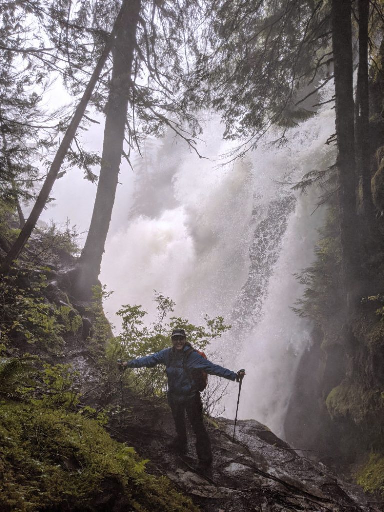
Mamquam Falls is the largest waterfall along the Mamquam River. It plunges into a bowl with cliffs on either side at the end of a pretty gorge. The river is regulated for hydroelectric power, so although you can see the waterfall year round, it is smaller than it would be naturally.
Type of waterfall: Plunge
Waterfall drop: 19m (62 ft)
Stream: Mamquam River

Mamquam Falls – Getting Started
The trailhead (click for google map) is at the end of Powerhouse Springs Road, off the Mamquam River FSR near Squamish. It is super close to Mount Crumpit, so you could add this as an extra kilometer from Crumpit Woods. The road is doable without 4×4, just take it slowly and be ready for oodles of potholes.

If you want to see the falls quickly, head straight to the bridge by the Altantic Power station. The loop we did goes off to the left from Powerhouse Springs Road, then turns right when you see the lego-like concrete blocks. Follow that trail down to the Mamquam River.

There is a picnic area down by the Mamquam River Kayak site. This is managed for kayakers by the Mamquam River Access Society but is not for camping, and there is no garbage disposal, so make sure to pack out whatever you bring and leave no trace. This part of the river was famous for kayakers long before hikers/tiktokers found it.

From the picnic area the trail curls around and heads alongside the river. The forest is typical BC coastal rainforest – mossy, green and gorgeous.


Mamquam River
You can walk right down to the edge of the Mamquam River. Just be careful as this river is swift and hazardous. We visited when the salmon were running further downstream, but we did not see any salmon up here.

From here you can hear the waterfall, and you’ll start to see it through the trees. The river is fed by meltwater from the Bishop Glacier on the east side of Mount Garibaldi, and the Mamquam Icefield. Those glaciers scrape and erode rocks into rock flour which is what gives the water the iceberg-blue colouring.


Mamquam Falls Viewing Platform
The best place to view the falls is on a concrete platform at the edge of the gorge. The tree to the left conveniently hides the power station. This might not be particularly wild, but it is a beautiful sight.

Be really careful on the trail from the viewing platform back up the the concrete bridge above. It is quite eroded and very steep (not really suitable for small kids or grandmas.) I spotted a culturally modified tree here as well as some cool slime mold.


Once you make it up to the bridge, you can look down on Mamquam Falls, and into the gorge. It’s pretty spectacular from here.


Other fabulous Squamish Waterfalls
I’ve made a map so you can find amazing waterfalls near Squamish and around BC. Green means you don’t have to walk, Blue is for waterfalls with easy walks and Dark Blue means you’ll need to do a slightly longer/harder walk to reach them.
Three of my favorites near here are:
- Shannon Falls – super easy as it’s right by the highway.
- High Falls Creek – You need to scale a cliff with a rope for this gorgeous waterfall
- Crooked Falls – An intermediate (but short-ish) trail to this stunning twisted waterfall


My controversial take; Although it was cool to see Mamquam Falls, I don’t think it is worth driving all the way to Squamish just for this. The other nearby waterfalls are all more impressive and feel wilder. Having said that, if you don’t mind the ugly concrete bridge and the power station, this waterfall is still gorgeous. The best way to visit Mamquam falls is as an add-on to another hike/road trip/adventure.
It sounds like there will be a new trail called the Squamish Canyon in 2025 that will make this area more accessible to the hundreds of tourists that visit. So watch out for that!


18 thoughts on “Mamquam Falls – Squamish”
Wow the pictures look stunning! This definitely makes me want to visit the next time I’m in the area!
Wow but those waters are beautiful tho 😍😍 That said, I totally agree with you, I really hate it too when you have a nice nature bit and then have to put up with ugly human-constructed bridges and stations and whatnot. The least they could do is architect it to be at one with its surroundings 😒
Squamish has so many beautiful hikes, and this is another one to add to my list. I’m a sucker for a good waterfall. Love that you saw a culturally modified tree! Gorgeous spot 🙂
Squamish sounds like a perfect destination to explore waterfalls for some breathtaking views. I appreciate Mamquam may not be everyone’s cup of tea but from your beautiful photos, I would love the hike up to the viewing bridge for a spectacular view of the gorge.
Love falling in love with random places I can’t pronounce 😂
Hard to believe it’s next to a power plant, but it sounds like a nice quick hike to such a beautiful waterfall.
Your photos are beautiful as always! Really appreciate your candid review. I’d probably still have to see it but makes sense to do so as an add-on to nearby waterfalls.
I feel like this is an area where we could easily spend hours exploring and enjoying the beautiful scenery!
Great post! Love the water color. I had never heard of a culturally modified tree before, that was really interesting to learn! I hope Grandma loved her trip to Canada 🇨🇦
We’ve seen trees like that all around BC – it is pretty cool to see how the tree can live on even after people have used part of its bark.
Wow, this looks gorgeous! The colour of the water is lovely. Saving this in case I ever get to travel to the area 🙂
I think it can be a LOT brighter on sunny days! The colour fluctuates as different amounts of snow melt fills the stream…
This is a new one for me, and looks like a nice short trail but good to know it might be best if already in Squamish for something else vs a day trip just for the trail. There’s so many around here, and I do like to spend time in Squamish too
Oooh yay that I got to show you a new one! It shows up on instagram quite a lot, but it is a bit less famous for hiking books. (Probably because it is less wild than the ones you need to hike to!?)
It’ll be interesting to see how it is all developed next year.
That water!!! And your waterfall map…I’m saving that. I was planning on going to Jasper this summer 🙁 Still want to hit the BC area.
I’ll keep adding to the map, so just save the link 😉
Oooh you know, the drive from Jasper to the coast in BC is stunning, so I hope you get to visit both areas. Hopefully Jasper will rebuild well after this years fire.
The falls look beautiful and the walk looks easy. That’s my kind of activity these days.
I love a good easy-ish hike with a big payoff like this one! The water looks beautiful in contrast with the green of the area. Will add it to my list!