Mount Seymour – Third Peak
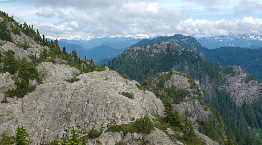
Mount Seymour’s Third Peak is such a fun mountain to explore near Vancouver. It is one of the most popular hiking spots near the city for several reasons; Firstly you can drive (or even cycle) most of the way up, so the alpine area is pretty accessible, even for beginners. It also has multiple trails depending how energetic you are feeling. You can take a stroll to Mystery Lake or Dog Mountain if you want an easy walk with great views. Or, if the weather looks good and you are feeling epic, you can continue on to Mount Seymour’s Third Peak. From the top you’ll be treated to seemingly endless mountain views to the north, as well as views of the lower mainland and Vancouver to the south.
Once you’ve hiked up Mount Seymour, you can easily spot it’s three main peaks from all over Van City. This will give you a daily dose of joy (or smugness) when you look over to the North Shore and remember how much fun you had up there.
Mount Seymour trail map
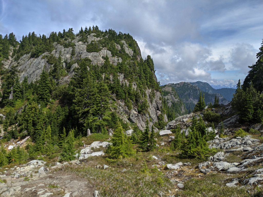
Mount Seymour is actually a chain of peaks. To reach the main summit, you need to go past Dinkey Peak, Brockton Point, First Pump Peak and Tim Jones Peak before you reach Third Peak. It is pretty perfect for newbie walkers as although it is steep, with plenty of rocks to scramble over, it’s not too difficult. If you want an even bigger challenge, you can continue even further to Mount Elsay and beyond.

Mount Seymour Third Peak – the basics
Distance: 8.5km
Elevation gain: 577m
Highest Point: 1449m
Time: 4.5-5 hours
What to bring:
The ten essentials (as always)
In early summer you’ll want bug spray too.
When there is snow, you can snowshoe up to Pump Peak, but Tim Jones Peak and Third Peak venture into complex avalanche terrain, so bring an ice axe as well as avalanche gear. Or save those peaks for after the snow has melted.
Facilities:
There is a loo in the car park at the start. In winter, there is a cafe too.
Dogs:
Good for dogs up to First Pump Peak, although the hike to Dog Mountain, is even better (even in the snow)! It’s a bit rocky for paws to the higher peaks.
How hard is it?
Moderate. It is steep and will get your heart going, but the path is easy to follow. There is some scrambling up to Third Peak.
Mount Seymour Third Peak – be ready to turn back!
You never expect to fail to make it to your destination, but it is really important to read your surroundings and turn back if it isn’t safe to continue. Mount Seymour has taught me this over and over again! The first time we hiked here (in June 2017) there was still over 8m of snow at the top of Brockton Point. We continued on to Pump Peak, but we didn’t think it would be safe to go further. Our second attempt started in the rain (but the forecast showed it would clear up long before we made it to the top.) However, the rain continued and we hiked right into the clouds, stopping at Tim Jones Peak with no views. The toughest section of the trail is between Tim Jones Peak and Third Peak. There is a thin ledge that you need to cross with steep cliffs in all directions. Avoid that section when it is icy or very wet.
It was only on our third attempt (in July 2020) that we finally had perfect conditions to hike to the Third Peak. It was worth the wait!


Mount Seymour Third Peak – getting started
Mount Seymour is one of the fantastic mountains that allow your car to do a lot of the hard work – the parking area is at an elevation of 1010m. It can be very busy at the weekend, so it’s best to start early. The nicest trail to hike up Mount Seymour is to the left when you leave the parking lot. Alternatively you can hike right up the ski slopes, but then you miss out on the pretty forest along the trail.
First Pump Peak
The first section of the trail was the busiest, so we didn’t linger for long at Brockton Point, or at First Pump Peak. I counted at least 15 people on First Pump Peak as we made our way past. We weren’t keen to get close to other hikers during a pandemic so we continued straight on.

Tim Jones Peak
The next peak along the trail is Tim Jones. Tim Jones Peak was re-named in January 2017 (it used to be called Second Pump Peak.) It is named after a paramedic and a leader of North Shore Rescue. Tim participated in more than 1,400 missions and he helped more than 1,600 people, so it’s pretty cool to wander up a mountain with his name on!
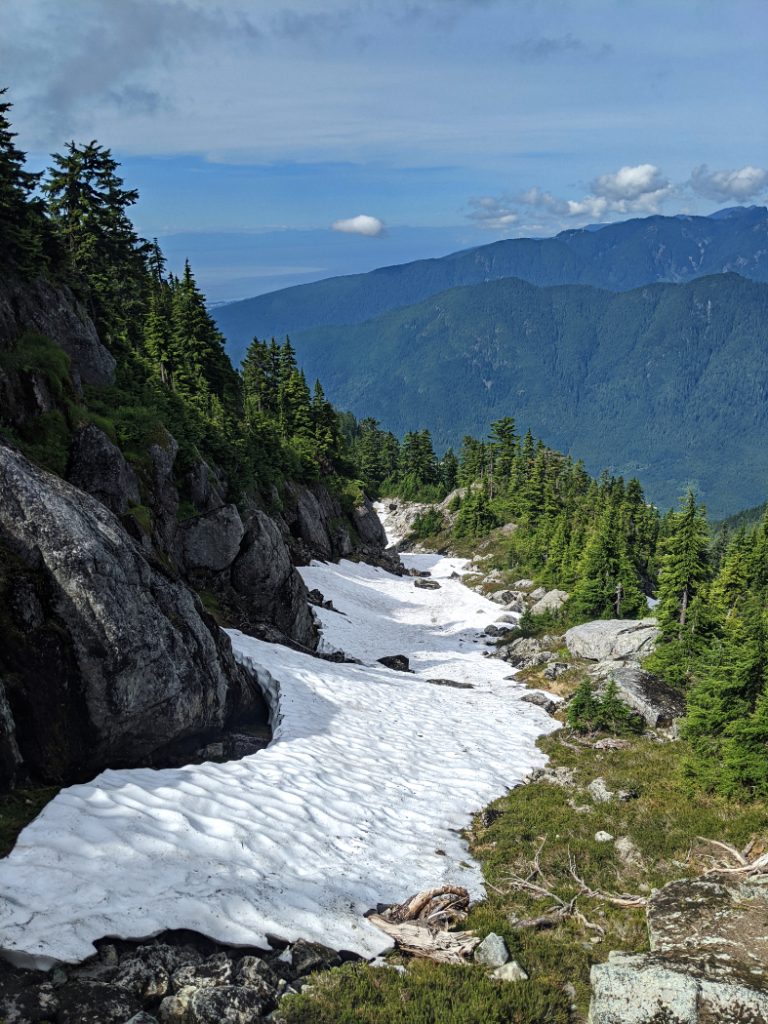
Watch out for snow
There were still patches of snow on this trail in July. Pack your microspikes (if you have them) even when it seems like summer down in the city. The trail goes straight down that snow/ice in my photo below. You can see the orange trail marker in the trees.

We finally got to see some views from the trail to Tim Jones Peak.
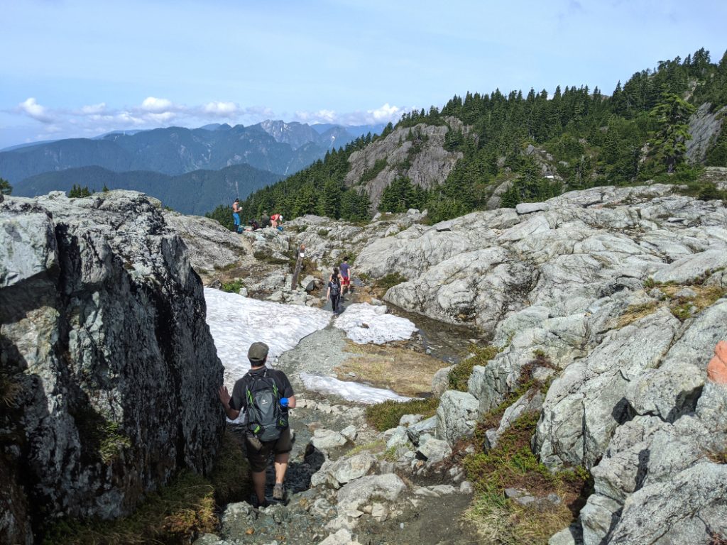
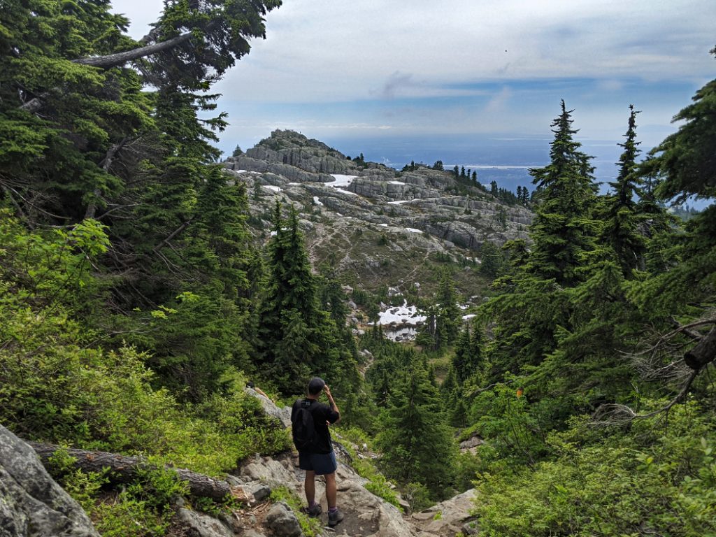
The dodgy section
This is the part of the trail that I found terrifying when we hiked to Mount Elsay! You need to walk along a rocky ledge above some cliffs. This is very dangerous and scary when it is icy. Even on this sunny day in July, we saw lots of hikers struggle with this section. You may have to wait while other people traverse this part in single file. My photo does not do this justice at all. It is super steep!

One bonus of dangerous cliffs is at least they give you a chance to see fabulous views of the North Shore Mountains. Once you’ve made it through the dodgy section, you can hike up the rocks to the Third Peak. There are fewer trail markers here so keep an eye on your GPS/map to stay on route.

The trail undulates quite a bit, so you’ll need to climb down, then up again between each of the peaks. This mountain may not have much elevation gain, and it is close to the city, but don’t let it lull you into a false sense of security. There are plenty of hazards with cliffs and snow patches to navigate. The photo below is between Tim Jones and Third Peak. It is pretty wild scenery for somewhere so accessible.

Mount Seymour Third Peak – the last push
To make it up onto Third Peak, you follow orange coloured paint splodges on the rocks. This is the view of the final bump you need to ascend for the best views. This looks a little more intimidating than it really is. As the trees at this elevation get snowed on in winter they grow very slowly and are quite small.

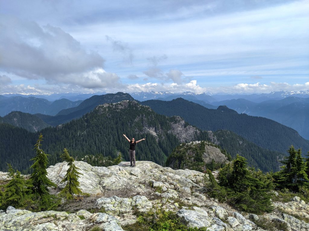
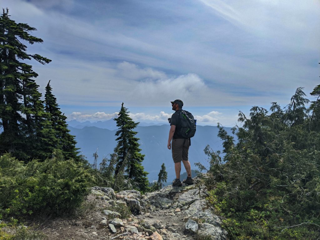
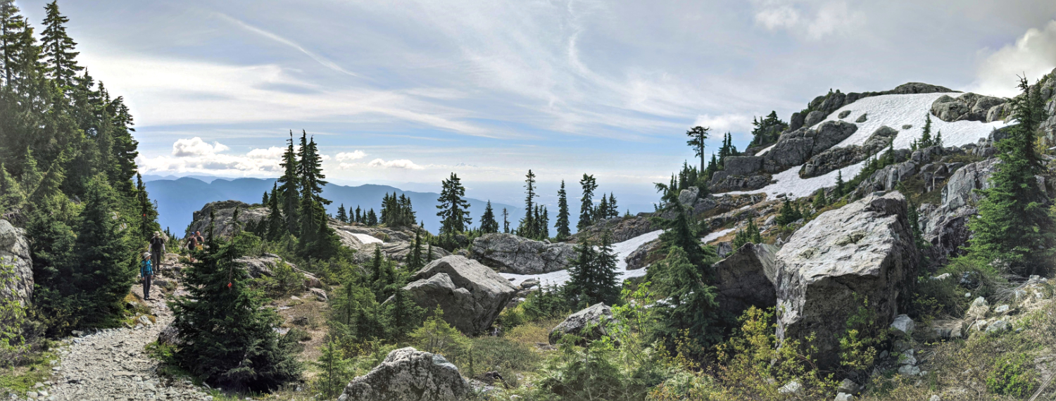
Mount Seymour Third Peak Views
We made it! The views looking north (and northwest like the photo below) are fantastic. You can see layers upon layers of mountains that stretch off into the distance for miles. This shows off Mount Burwell and Cathedral Mountain off in the distance. You can also see how much you need to climb down (and then up again) to reach Mount Elsay.

This is the view looking west, with Vancouver on one side and the North Shore Mountains in layers next to it. The closest ridge is Lynn Peaks and the Needles. The ridge behind that is Mount Fromme and Grouse Mountain.

Then looking north, you can see Mount Elsay followed by all the ecclesiastical peaks (Rector Peak, Curate Peak, Vicar Peak and Mount Bishop)

This is a pretty fantastic lunch spot. We spent quite a while sitting, eating and taking in these fantastic views.

There are even a bunch of teeny peaks to the east of Mount Seymour. I have hiked to the smallest of these, Mount Underhill. Most of the others don’t seem to have names.

Mount Seymour – Heading back
Once you have taken in the views, you return the way you came, back past all the other peaks. The view below is of First Pump Peak from the trail on Tim Jones. Pump Peak was even busier when we went past in the late afternoon, so we skipped it again.
How busy is Mount Seymour?
Mount Seymour is basically always busy; But it can get quite crowded at the weekend especially on the lower, easier trails to Dog Mountain, Brockton Point and Pump Peak. Having said that, once you go a little further to Tim Jones and Third Peak, the number of hikers thins out. If you continue on to Mount Elsay, the trail is very quiet. We started early in the morning so we only really noticed how busy it was for the final hour as we descended.
As long as you expect there to be a bit of a hiking party here, you’ll have fun. If you decide to hike here in search of peace and quiet, you’ll be a bit disappointed.
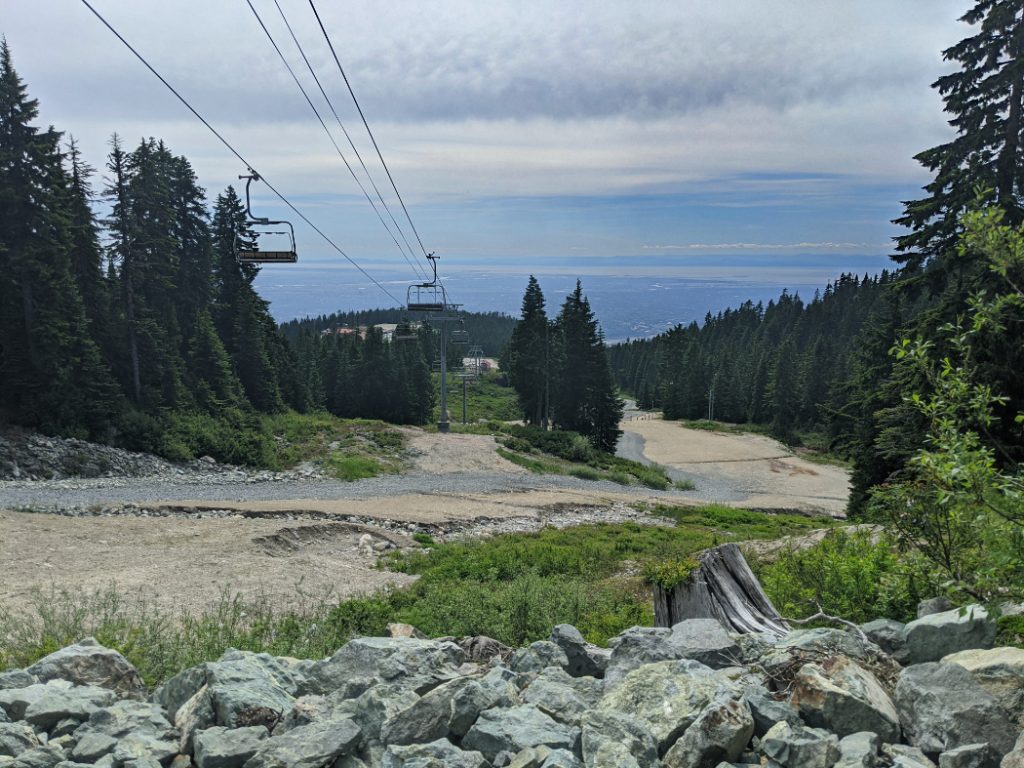
We often hike down the ski slopes when it is busy on the main trail. This has the extra advantage that you get a few last views down to Vancouver.
Mount Seymour Panoramas
I will finish with a couple of Panoramas I stitched together from my photos.

I’m glad we finally made it up Mount Seymour’s Third Peak. It may have taken us three attempts to reach those epic views; But it was totally worth it. Do you like the look of this trail too? Or, do you have a similar nemesis hike in your area that took multiple attempts before you made it to the top?
If you’d like to learn more about the fantastic possible hikes nearby, read my introduction to Vancouver’s North Shore Mountains, or see my Canada page for more BC hikes.
As always, click on the pins below to save them.


53 thoughts on “Mount Seymour – Third Peak”
What a beautiful place. Is this hike easy?
It sort of depends how much hiking you do, and if you are used to steep mountains. It is one of the easier trails on Vancouver’s North Shore, but it’s still pretty tiring and has some challenging moments.
I’d class it as intermediate.
If you need an easier option, you can just stop at Brockton Point or First Pump Peak. 🙂
Lovely! This makes me want to go hiking!
Yay, anything that makes you want to hike is a win for me!
wow those are some serious views! definitely looks well-worth every effort!
Thank you! They are fab aren’t they!?
This is the second time I stumble upon your hiking post and wow what a beautiful place again! I am not much of a hiker, but I’d do anything for a view 🙂 Will save this post for later!
Lol I know what you mean, I looove finding good views. If you like the views but want an easier option, you can always head to Dog Mountain. It starts at the same trailhead, but is much shorter and doesn’t have as much up/downs.
Josy, I am sitting in my arm chair but my knees went to jelly when I saw your steepest bits. Please be very careful. Dad says keep away from bears! They must be waking up by now and a Josy would be tasty after a long sleep. Love, Lis
Hi mum!
This is close to where we were when we called you on Sunday! Don’t worry the bears seem to be avoiding the snow still.
I wanna live where you live Josie. The scenery is astounding and so beautiful. Wonderful photos of a great hike.
Once things reopen, you should come and house sit here. I know you’d both looove the hikes.
Love how in-depth you go about specific hikes and the photos you share from different places. Makes me feel like I’m there with you!
Thanks Cass!
I’m aiming to make them useful both for people who are planning to do the same hike, but also for people that just like seeing the views without actually hiking. I am really chuffed if reading makes you feel like you’ve visited. Woot woot. 😀
Looks like another great hike! This reminds me of my “nemesis hike” up the back side (the hard way) of Black Elk Peak in the Black Hills. Glad I’m not the only one who turns back sometimes. (Actually the rocks look kind of similar to the Hills, are they granite?)
Yeees I remember your post about that one! I have a feeling that is way harder than Mount Seymour. We just had bad conditions on the first attempts when we failed. The Northern Route of Black Elk Peak sounds hard even if you have fab conditions.
What a spectacular hike! Those views look stunning but I’m not confident I could navigate that dodgy section. That looks pretty hair-rasing from the pictures! Thanks for sharing your guide!
You do so much hiking Hannah, I am sure you’d be fine! It wasn’t so scary in the summertime when we did this hike. I just wouldn’t attempt it if it’s rainy or icy.
These views look incredible! I also really appreciate that the trail is easy to follow. I’ve gone off course on trails a few times and it’s frustrating!
Me too! Lol it even happened yesterday!
It’s still possible to go off route on Mount Seymour, but luckily they do have plenty of trail markers.
I have been to Vancouver and love the city and the island! This hike to Mount Seymour sounds fascinating! The views from the top are stunning. I will look up this hike when I am in the vicinity next. 🙂
Yay Jan! I hope you like it.
What a beautiful hike! That section on the cliffs definitely looks a little scary but the views definitely look worth it!
Thaaank you! Yeah, the cliffs can be scary but totally worth crossing for the views.
Thanks for the great guide for this. This is a hike that is on our list for this summer! So many incredibly beautiful places to go hiking in BC. Always takes my breath away 🙂
Oh yay! I hope this helps Debbie!
I didn’t know this when we visited, but there is a place you can swim on the way back (at Mystery Lake) if you fancy a dip after your hike. I’ll try that if we go again this summer.
I made it as far as First Pump Peak late last year. We set off later in the day and then took a wrong turn up a ski hill which cost us time so ended up settling for the first peak and vowing to return. I still need to do that but not sure about that dodgy steep section. I might have to take a couple deep breaths for that bit
Just like us! We only made it to Pump Peak the first time we visited. Hopefully it won’t take you so many attempts to go back!
If you fancy a real challenge this summer, have a peek at Mount Elsay. It’s the same area, but soooo fun (and hardly any other hikers.) It is exhausting…but you managed the Lions by mistake, so I am sure you could do it!
What an amazing hike! So crazy that there can still be snow on the trails in July! That must be amazing to see. It seems like such a beautiful trail to hike, and even though it’s quite long it seems like I might even be able to do it!
Yeah that really surprised me too when we first moved here. Now I love it – you get a cool breeze above the snow, even on super hot days.
The Pacific Coast is undeniably one of the most beautiful areas. Hiking there looks AMAZING! I appreciate the warnings you give on turning back if the conditions are not ideal.
Thanks Ildiko! Yeah, the mountains are always there if you have to go back another day.
Great post! I’ve never been to Canada but I’ve always wanted to go. I’ll have to save this post for later!
Thank you Krystianna.
Always love seeing your hiking trails in Canada, these trails are stunning. Can’t wait to be able to visit the country and explore these trails.
Thanks Kiiti!
I hope you can visit, I always love your hiking photos, so I’d love to see these trails through your lens.
What a gorgeous hike, thanks for the photos and the tips! I can’t wait for a safe reopening of the border, I’m just south in Seattle. But, yikes, that steep spot looks tough. I’m glad you made it all safely and appreciate the post!
Thank you! Yay for hiking neighbours. I may have to pick your brains about adventures South of the border when things reopen. 🙂
Those are indeed wonderful photos and I am glad you enjoyed this hike. The part with the steep drop-off is the place where I would have turned around. You say Mt Seymour is always busy – I guess this is the non-busy part starts.
I don’t think I’d ever get used to there always being snow at the top of the mountains. 8 M of snow in June! Your photos from your successful hike in July 2020 are incredible. Thanks for the gorgeous photos and the fair warning about busyness.
Good one! I totally enjoyed reading your post. Beauifully captured pictures of scenic landscapes!
I have read many of your hiking posts before, and they make me jealous. Canada has so many amazing hikes. It is hikers paradise. Beautiful.
Awesome blog post! This hike sounds like the effort to climb is 100% worth it for the views!
I’m glad you had success after your persistence. It’s hard to turn back sometimes but always better to save it for another day instead of taking big risks. Beautiful views.
I’ve never heard of this trail before. The view from the top looks amazing. And what I love about it is that you don’t have to do all the grunt work so beginners can enjoy it as well.
Ok, first of all, I had no idea Vancouver was referred to as Van City! lol Also, this trail looks so fun – a good scramble. I can imagine it’s a bit dodgy if the conditions aren’t right. Glad you were able to make it all the way this time!
It’s nice that Mount Seymour is so close to Vancouver! It’s very cool that you can see it from the city as a reminder. That’s too bad though that rain or snow can prevent hikers from getting to the top, but it did make me laugh that you labeled the worst part of the hike “the dodgy section”! I love that the views here are a little more rocky and not just an ocean of green pine trees.
Ahh, so pretty! I like that there’s a variety of trails so you can choose based on whatever difficulty you’re looking for! I’m definitely adding this to my “Someday” list! *-* + fingers crossed for good conditions 😀
Yaaaay! If you come in the summer it is normally fine. 🙂
Wow, you guys are certainly ambitious. The views are fantastic but that icy drop-off? No thank you. Especially if you have to cross it again on the way back. I’m pretty sure that’s where I’d run into trouble. But, I love that you can drive up to the trailhead. I’m a lazy, fair weather hiker.
As always, thanks for sharing your lovely photos.
Patricia Rickrode
w/a Jansen Schmidt
It was so helpful reading your article.
We did this hike today, and your guide was super helpful! We planned to arrive about 8am, but didn’t get to the trailhead until 10 – it was perfect timing as the morning people were coming down and the afternoon hikers hadn’t started. So it wasn’t too crowded for a sunny Saturday!
Oh yaaaay! I am glad it helped! It is such a fun trail isn’t it. I am glad you were able to make the most of the sunshine. 🙂