Faja de Pelay Hike – Ordesa Valley
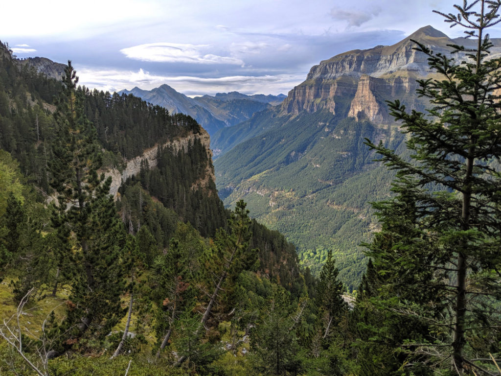
 The Faja de Pelay is one of the most gorgeous areas to walk in Ordesa y Monte Perdido National Park within the Spanish Pyrenees. The pathway is on a ledge halfway up the Ordesa Canyon, so you will be treated to fantastic views down into the valley, and over to the opposite cliffs.
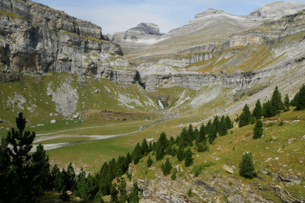
We explored the Faja de Pelay as part of a really fun 28km loop with epic views. We started walking past all the waterfalls in the Ordesa Valley Hike to Cola de Caballo, climbed up to Refugio Góriz and then returned to the car park via the Faja de Pelay hike, half way up the Canyon walls. It was all pretty spectacular.

Faja de Pelay Hike – the basics
 Distance: 14.2 km (one way) or 12 km if you don’t hike up to Refugio Góriz.
Elevation loss: 650m
Cumulative elevation loss: 1250m (as you gain over 600m going up on the way down)
High Point: 2160m (Refugio Góriz)
Time: 4-5 hours (one way)
What to bring:
Water, snacks and your camera!
Hiking poles to help your knees.
The 10 essentials.
Facilities:
There is a toilet in the car park and at Refugio Góriz.
Dogs:
Great for dogs, but keep them on a lead.
How hard is it?
The top end of intermediate. The path is easy to follow, but has steep drops and is haaard on your knees with the 1250m elevation loss.
Maps:
Spain has fantastic maps that you can download or use the Mapas de España app. We also found the Maps Me app very useful, especially as you don’t need data to use it.
Faja de Pelay trail map
The map below shows our entire day-hike, rather than just the Faja de Pelay section. You can read the first part of the hike to Ordesa Valley Hike to Cola de Caballo here. Then, the second part about hiking up to Refugio Góriz here.

Faja de Pelay Hike – Possible variations
The Faja de Pelay Hike is one of the most famous walks in the Ordesa y Monte Perdido National Park. We traversed it backwards, using this path to return from Refugio Góriz after our hike to the Cola de Caballo waterfall. Still, I think this would also be a fantastic walk if you did the whole loop anticlockwise. To do that you’d need to start with the steep climb up to Mirador de Calcilarruego (an amazing viewpoint), walk along the cliffs and then return via the path with all the waterfalls at the bottom of the valley.

Faja de Pelay Hike – How hard is it?
When you see photos of this hike it looks pretty scary, with steep drop-offs looking down from the cliffs. If you are afraid of heights, then I think this might feel terrifying BUT the path is never very exposed. I didn’t feel like it was dangerous at all.
However I found all the downhill sections to be a bit of a jelly-leg inducing challenge on my knees. The elevation loss of 650m does not sound so bad, until you realize just how much the path undulates. Once you add in all the uphill sections, you’ll be losing over 1250m in elevation, which can feel tough on your knees. The hardest part is the final 2.2km, when you lose around 550m. There are plenty of switchbacks, but it felt pretty painful to me.

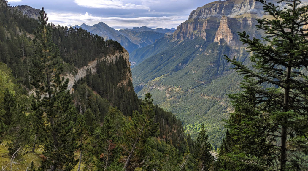
Faja de Pelay – the hike
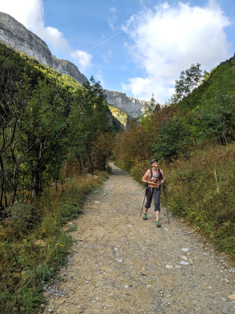
From the waterfall, Cola de Caballo, follow the path named Senda de los Cazadores towards the Faja de Pelay. There is a slightly scary sign at the start to warn people that this is a dangerous path, that you should not start after 3pm. The path slopes up gently, so pretty soon you’ll have fab views of the Ordesa Valley.
The canyon views are fantastic right from the start!

This is the view looking backwards to Circo de Soaso and the Three Sisters – Cilindro (3325m), Monte Perdido (3355m) and Añisclo (3254m) – the largest limestone massif in Europe.

I loved looking over to the cliffs on the opposite side of the canyon.

You can see although the drop off is pretty steep, it’s not *too* scary.


Wildlife
One of my favourite moments was when we saw some Pyrenean chamois on the trail. These are goat-antelopes, and they were really sweet to watch as they munched their way through grasses! Earlier in the day we’d seen marmots (I love marmot-dudes!) we also saw squirrels, a snake and some lizards.

Wooded sections
My best photos from the Faja de Pelay are from the open sections of the trail. However the pathway is in the middle of the tree-line, so there are quite a few moments when you hike through forest. We were pretty tired by this point, so we stopped at one of the viewpoints for an apple and to relax for a while. Unfortunately the light was starting to fade, so we had to speed up again.
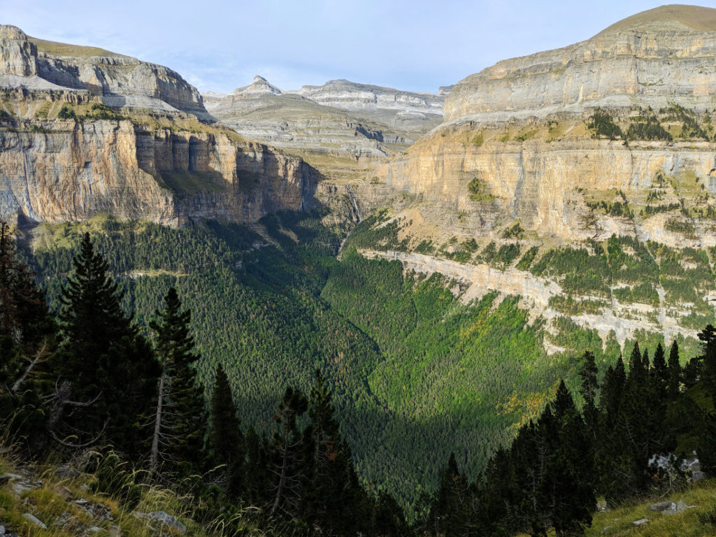
Faja de Pelay views
It may just have been the start of golden hour, but the last few kilometers on the trail, to the Mirador de Calcilarruego viewpoint, were gorgeous.
See what I mean?

This is one of the final views before we had to start heading down.
Mirador de Calcilarruego viewpoint
We made it to the gorgeous viewpoint before the sun started to set.

If you decided to walk this in the opposite direction, this viewpoint would be after a tough climb from the car park. For us, it was the last mini rest before our grueling descent.
Get ready for jelly legs
The final 2km was the only part of our day that I did not enjoy. My knees were a little painful after the 650m we had already descended, but there was still 550m to go down.


A great tip for if you knees hurt, we found that if we run down trails, it puts less pressure on our knees. This means you get a little longer before they turn to jelly. The top section of this was so steep that it was difficult to run, but as you get further down, the multiple switchbacks make it less steep and easier to pick up speed. My knees still hurt, but much less than if we had walked down.
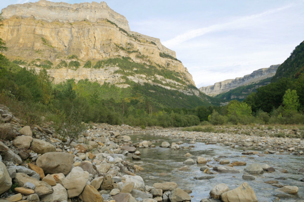
Marc was much quicker than me, so by the time I’d returned to the River Arazas, he had his boots off and his feet cooling down in the water. I did attempt to join him but it is SO COLD!

I hope you like the look of the Faja de Pelay. It was a fantastic day in the Ordesa Valley.
If you are planning on spending some time in Spain, you should definitely take a peek at the ridiculously beautiful national parks. Ordesa y Monte Perdido National Park was a complete pleasure to explore. Please click on the pins below to save this walk for another day.

49 thoughts on “Faja de Pelay Hike – Ordesa Valley”
Stunning place! I’ll never do these hikes so it’s great to see these places through your photos.
Thanks Coral! I love sharing photos so I am glad you like them.
If you ever visit this area and want to see similar views, you can be taken in 4x4s up to the top of the canyons(!) So lots of those amazing views can be seen without actually hiking. (Just in case you do want to see them…)
Wow Josy ,your hikes always inspire me do take up hiking experience and do more of it.this one looks really amazing ..the valley is so pretty although steep but must be a great experience
It does look a little scary and steep but the views are outstanding aren’t they? Love the term jelly legs too, exactly what they feel like after a long days hiking.
Thanks Jonno! The views made us both sooo happy!
I think it is the way my legs wobble after tough downhill sections. They always feel a bit jelly-like to me. I have to admit, I get jelly-legs less often now I’m more used to mountains, but they still hit me sometimes!
I would love to see the antelope goats!
They are super cute aren’t they?
Incredible photos and so informative. I’ll have to add this hike to my list “One Day”. Never knew Spain had such hikes.
Thanks Nicole! I hope you get there (if you’re anything like me, you’ll have a looong list of “one day” hikes!!
I saw the photo of the hut you took. Is it possible to spend the night there and if so how would you go about it?
Yep, you can definitely stay the night (and fill yourself with tasty Spanish food while you are up there!)
They have 80 bunk beds, and you can reserve spots online here; https://www.alberguesyrefugios.com/goriz/reservar or more information about it here: https://www.goriz.es/instalaciones-y-servicios-del-refugio-de-goriz/
Your photos are so gorgeous. I love the colour of the rocks with the greenery and the fall colours starting to show. I also like how open much of this hike is with the grand views. Thanks for clarifying about the steep drop-offs but never feeling like the path is too exposed (my hubby is not a fan of heights but I think he’d be OK with this…and best I don’t tell him beforehand).
I did read a review on trip advisor that said this path is really scary for people that are afraid of heights, so if you take your husband, it might be worth showing him photos first, so he knows what he’s getting into. I didn’t find it exposed, but I guess it might feel exposed if you are not a fan of drop-offs(!)
Incredible! Seems like tough hiking but probably 100% worth the views!
This part isn’t even *too* tough! It was totally worth it. 😀
Your photos are stunning and made me feel like I was on the trail through your eyes. I love the pic with you, shoes off, feet hovering over the icy river water.
Yay! I’m so glad you liked it Razena! That water was sooo blooming cold, but at least it was refreshing.
This looks like such a beautiful place. Great pics!
Thanks Chelsey!
Wow what a beautiful place! Stunning nature!
Thank you! It was such a fun day!
Wow – what fantastic views! No wonder that first pic is one of your favourites – it looks stunning, especially with that splash of autumn colour in the trees.
It’s pretty good for such an accessible walk isn’t it! This part did kill my knees on the way down, but those views were totally worth it.
Definitely! Your poor knees though… I’ve found that working on improving my leg strength (especially hamstrings and glutes) has really helped ease the pressure on my knees on descents. Could be worth looking into to protect those vital knees!
I have been meaning to do more leg exercises to get ready for skiing, but oooh it’s good to hear it might help my knees too!
Wow, those photos are amazing Josy! Such beautiful views. Would love to go here when I return back home to Europe!
Thaaank you! This was at the end of the day, so it’ll probably be even prettier in the good light of the morning(!) I loved all the steep drop offs.
Those Canyon walls are incredible! As if the landscape was folded into shape. Looks like a spectacular hike. Plus the wildlife! The chamois looks super cute. The best reason to stop and cat h your breath for a while 🙂
Thanks Mararita! I toatlly agree, seeing animals on the trail always slows us down to a photo-taking crawl!!
Wow that looks incredible! I had no idea that Spain had rugged mountains like these – definitely added to my bucket list!
That looks like the perfect hike! I can’t believe I missed this when I was living in Spain – but just one more reason to go back!
I love those kinds of excuses! <3
I haven’t been to Spain yet but it’s so good to know that there are amazing hiking options beyond just exploring the culture & cuisine 🙂 Thanks for sharing your experience!
This is amazing Josy! The incredible views and photos, it’s definitely a perfect hike but not yet for a novice like me 🙂
You know, I think this is actually totally doable even if you are not used to hiking. You could just do this first (so in the opposite direction than we did it)
My parents did this trail when I was two with them carrying me in their shoulders! There are some pics of it but they are definetely not as outstanding as yours. It always amazes me how unknown these mountains are considering the landscapes we have!
That is awesome! Could you go back with your parents and re-live the walk you did as a little’un!?
I totally agree about the Spanish Pyrenees. There is so little written about them in English. Even once we knew we wanted to explore here, it was hard to find good information about possible routes. The landscapes were spectacular, so I hope more people get to hear about these fantastic hikes.
What gorgeous views! I’d love to hike it some day.
Yay! Thanks Mona!
gorgeous! thank you for the post. do u know if this trail is open mid march? will be visting then and hope to experience the same!
I am not sure. I think it will depend on how much snow they have this year. There might still be snow there in March-April. That may still be fun as long as you have the right equipment (with things like microspikes)
I hope you have an amazing trip!
Que descrição maravilhosa. Conheço o Vale de Ordessa por baixo. Já é lindo. Imagino por esta trilha no alto. Numa caminhada em montanhas, é indispensável um par de bastões. Eles são o melhor aliado dos joelhos.
Quanto a descer correndo, quando eu estava subindo até a base do Fitz Roy, em El Chaltén( passeio imperdível), vi uns malucos descerem correndo. Quando chegou a minha vez de descer, eu entendi perfeitamente a razão. E me pus a correr montanha abaixo.
Outro lugar imperdível na Espanha, são os Picos de Europa. Lá destaco a fantástica Ruta de Cares e subir no teleférico de Fuente Dê.
I am so happy I was able to find your post about doing this hike as a loop and staying at the Refugio Goriz then coming down the opposite way. I think your loop includes the Cola de Caballo and the Faja de Pelay right?? a few questions please:
Do you get to the Miradore de Calcilarruego lookout from this hike? They said that this lookout is at the end of the Casada Cola de Caballo hike. Are there any ferettas? I hope you are still hiking!
Hi Lynn,
Yes exactly! We went up to Refugio Goriz via Cola de Caballo, then back via Faja de Pelay. Yes, the Miradore de Calcilarruego is right at the end before you start the steep hike down. There were no ferettas on the route we took, but I am not sure if there are some on the climbing route up to Refugio Goriz (we took the hiking trail, rather than the climbing trail.
We did it all in a day, but it would be lovely to do the same route with more time and spend the night up there.
One extra note, if you have knees that find steep descents hard work, the last section from Miradore de Calcilarruego down to the car park might feel hard. If that is the case, doing the route backwards might be better. You’d have a heart-pumping climb at the start, rather than a tough descent at the end.
Thank you so much for your information. We have time for one more home in the area. Do you have any suggestions?
Are you staying in Torla? The other amazing loop we did was from there. I don’t know if this is a famous hike – we just looked at maps and made it up https://www.awalkandalark.com/miradores-de-ordesa-loop-via-broto/
Oooh or, if you want to do via feratta, you could try the Via ferrata del Sorrosal in Broto. I didn’t try it, but it looked really fun from below.