Ordesa Valley Hike to Cola de Caballo
 Ordesa y Monte Perdido National Park is a ridiculously beautiful area in the Spanish Pyrenees that has countless hiking trails of all levels, from easy-peasy to truly epic. We stayed in Torla (a village on the edge of the National Park) and explored as much as we could. The walk I am about to describe is a fantastic introduction to the area. You will be treated to a hike through pretty deciduous forest that is surrounded by massive canyons. You’ll get to see at least five waterfalls before emerging in the Ordesa Valley with views up to the 3rd highest mountain in the Pyrenees, Monte Perdido.
Marc and I tend to get distracted by fun sounding detours, so the walk we did began with this hike to Cola de Caballo, but then we kept going and did a hike that was around 28km and around 1230m cumulative elevation gain. I am not sure how many people want to walk quite that far in one day, so I have split our adventure up into more manageable sections.

Ordesa Valley Hike – the basics
 Distance: 9.4 km (one way) we came back via a different route
Elevation Gain: 353m
High Point: 1770m
Time: 3-4 hours (one way)
What to bring:
Water, snacks and your camera!
The 10 essentials.
Facilities:
There is a toilet at the trailhead.
My map says there is a bar too, but it was not open in September.
Dogs:
Doggy heaven, but keep them on a lead
How hard is it?
Intermediate (as it is at least 20km depending how you return to the trailhead) The path is easy to follow and never gets very steep.
Maps:
Spain has fantastic maps that you can download or use the Mapas de España app. We also found the Maps Me app very useful, especially as you don’t need data to use it.
Ordesa Valley trail map
The map below shows our entire day-hike, rather than just the first part in Ordesa Valley. You can read the part about hiking up to Refugio Góriz here, and about our return via Faja de Pelay here.

Ordesa Valley Hike – Getting Started
The hike to Cola de Caballo starts at the Pradera de Ordesa car park. In the summer you are not allowed to park here, so you’ll need to walk, or take a bus or taxi from the village of Torla-Ordesa. However we visited in lake September so we could drive right to the start of the hike. Looking up from the car park, this was our first view of the amazing Ordesa Canyon.

Cascada de Arripas Viewpoint
The hike starts off in the forest, with occasional views of the River Arazas and the steep canyon walls. The path starts off pretty flat, then slowly climbs through the trees up to the first waterfall view of Cascada de Arripas.


Extra Waterfall viewpoints
If you have some extra energy, you can take a mini detour from the Ordesa Valley hike to two extra viewpoints for the Cascada de las Cuevas and the Cascada del Estrecho waterfalls. We always love seeing waterfalls so we did all the possible detours!

Cascada de las Cuevas
You climb down to this fantastic view of Cascada de las Cuevas (the caves waterfall.) Isn’t it gorgeous?

Cascada del Estrecho Viewpoint
The next waterfall cascades down through the canyon, so you will hear it long before you get far enough down to see it! I did attempt a jump shot. but it was still early in the morning with little light at the bottom of the Ordesa Canyon, so I’m a bit blurry. You get close-up views of this waterfall later, but we both loved this view from below.
Ordesa Valley Hike – time to ascend
Once you have taken a peek at these waterfalls, you continue to climb up on zig-zagging paths through the forest. The route never gets very steep, but it is a continuous climb. You’ll be able to manage it. Just take plenty of breaks if you get tired.

Whenever you stop for a breather, if you look up, you’ll get fantastic Canyon views.

More Cascada del Estrecho Viewpoints
You will go past a couple more viewpoints of the Cascada del Estrecho waterfall. The best spot allows you to look down the falls to the canyon below. I can only imagine this is even more impressive earlier in the year when the snow-melt swells the river.


You won’t see much of the next waterfall (Cascada de la Cueva) as it is slightly hidden in the trees. However after that point you are far closer to the Ordesa Valley so the path becomes easier and less steep. I loved the area with a path under an overhang of the canyon above.

Ordesa Canyon and Río Arazas
The path continues at the bottom of the Ordesa Canyon along the River Arazas. You will see the Canyon walls towering above you, and you get glimpses of the Gradas de Soaso waterfall in the distance.

Cascada Gradas de Soaso
The next waterfall of the day moves up the mountain in a series of steps. This was a great spot to stop for a break and admire the water.


The path climbs up alongside the Gradas de Soaso, so it seems more like a series of mini waterfalls than one large one.

The steps are made by horizontal rock structures that have been eroded away in layers to create this beautiful waterfall. I really liked the confused shark face I found in one of the rocks, but if you look carefully you’ll be able to find fossils here too.
Ordesa Valley
After the next mini climb you will emerge at one end of the Ordesa Valley, looking up to Monte Perdido. This was easily my favourite part of the trail. You can really see how the glaciers carved out this amazing scenery.

Isn’t this stunning!?

My photos make this scenery look empty. In fact there were quite a few other hikers around. Still, it was not busy at all compared to the walks we are used to in Canada. Especially when you consider how easy the walk is and just how amazing the scenery looks.

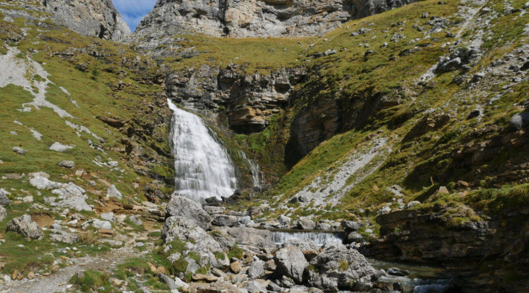
Cascada Cola de Caballo
The waterfall at the end of the Ordesa Valley Hike, the Cascada Cola de Caballo is the highlight of the entire walk. It looks a bit like the tail of a horse, so I can totally see how it got it’s name.


This is one last look back up the Ordesa Valley from above the Cascada Cola de Caballo.

There are a few possible routes to return from this point. If you have plenty of energy you can continue on to the Refugio de Goriz, hike back along the Faja de Pelay halfway up the canyon walls, or return the way you came.
Why Spain?
Marc and I just returned from our fantastic trip to Spain. We met up with both sets of our parents and explored the villages where Marc’s mother (and grandmother and grandfather) grew up. We had a few hiccups (including being stuck in Gatwick Airport for 9 hours, almost losing Marc’s bag and then both getting violently sick) BUT we both had so much fun exploring that I only really have good memories. This is just the first post about our time in Spain, but stay tuned I have plenty more on the way! Stay tuned for more amazing views of the Pyrenees.
Click on the images below to save this post.


30 thoughts on “Ordesa Valley Hike to Cola de Caballo”
This looks so fantastic I immediately had to look it up on a map. The hike sure has a lot of variety, but I’m with you: the scenery as you emerge in the Ordesa Valley is just magnificent. Late September looks like a perfect time too.
Late September was amaaazing. There were no bugs and the temperature was just perfect. I have a feeling we may have melted earlier in the summertime!
So scenic and I love all the water views!!
Thanks Pamela! Me too, the waterfalls were beautiful!
Don’t we live on a beautiful planet I miss my hiking days! Hubby trying to make me get new knees! 😁
I feel like I may need new knees too at some point! These ones have been taking a battering!
Always wanted to go to Ordesa Valley – Now I know why ♥️ Great photos!!
You are much better than me Hanna! I had never heard of it until I started searching for possible hikes in the Pyrenees. As soon as I saw those amazing Canyons, I was keen to visit!
I love hiking, and this makes me want to this country to do this.
Gorgeous photos, glad you and Marc enjoyed hiking there
We looooooved it Araceli! I can’t wait to start writing up info about your area too though!!
I’ve been saving up your Pyrenees posts to binge read them over a morning coffee 🙂 This looks like great hiking, so much easier than the Coast Mountains!
Yeees! The mountains here were such good training. We found we could manage much higher elevation changes as the paths are so good (and not crazily steep!)
But this one was just fun and easy… until we carried on up to the refuge!
Yeah, there’s no doubt that the BC Coast Mountains toughen you up and change your concept of what a tough hike is
These landscapes are absolutely gorgeous! I feel like walking this will give me sore feet. But by looking at the breathtaking landscapes, fauna & flora (I’m sure you’ve seen some interesting birds and insects), lush waterfalls, I’m sure the soreness (if any) will be worth it.
You probably wouldn’t even get sore of you just did this part! There was elevation gain, but it was never very steep.
It’s just if you keep going to the hut, and along the top of the canyon *that* was what made my muscles work hard!! 😉
What an incredible looking hike! It’s now on my bucket list. Looks so stunning, and with that scenery, 28km will fly by!
If you like the look of this, you might love a mini road trip with hikes in Spain/Catalonia. I was soo impressed with all the hikes we found.
Very beautiful area. I need to do more Spanish exploring and this is right up my street. Good work.
Eep! I am so sorry I didn’t respond to this earlier, but thank you for the lovely comment. 🙂
These are gorgeous! I didn’t realize Spain had areas like this. I’ll have to put this on my “to-do” list too!
This looks like an incredible place. So many waterfalls. Missed this when I hiked in Spain but won’t next thing.
Wow, what a gorgeous place! And the waterfalls are stunning. I don’t when/if I will get to Spain, but I’m definitely putting this on my list.
Wow, wow, wow. This is definitely going on the bucket list – I love me a good waterfall.
Yaaaay! I’m so glad you liked it too Riley!